Localized flash flooding concerns for Friday
The humidity departs on Saturday

Synopsis
A cold front backs in from New Brunswick early on Friday and is expected to stall across the Great North Woods/Baxter region southeastward near Eastport. A cold front approaches from the west late Friday afternoon and sweeps the stationary front to the east overnight into Saturday. Another cold front enters from the northwest late Sunday and passes to the southeast on Monday. A broad area of high pressure enters from the northwest for Tuesday and Wednesday, then moves east on Wednesday night. Low pressure is expected to enter the region from the northwest on Thursday and may bring unsettled conditions through Friday.
Forecast confidence through Tuesday: Fair
Forecast confidence Wednesday onward: Low
Potential Impacts
Potluck showers and thunderstorms are possible on Friday. Thunderstorms may contain heavy downpours that may cause localized flash flooding. Severe chances: Very Low. Flash-flooding chances: possible in areas that recently received heavy rainfall and where storms backbuild and/or repeat.
The humidity rises on Thursday, then drops marginally on Friday in the far north, then departs with the cold front on Saturday.
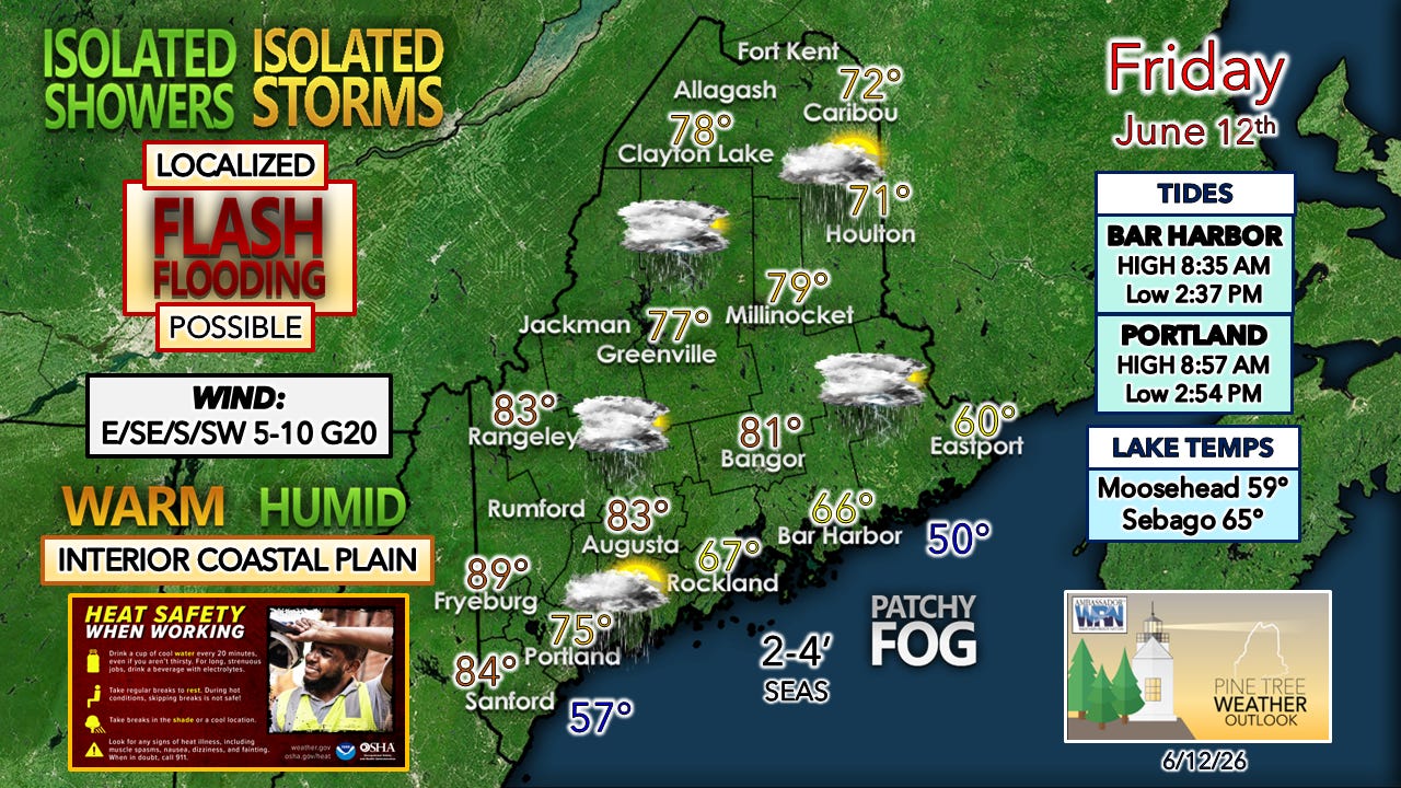
A Heat Advisory is in effect for southern Oxford, interior York, and interior Cumberland Counties through 8 PM Friday. Those with sensitivity to heat should take necessary precautions.
Areas of fog are possible for the coastal plain on Friday, and elsewhere overnight and early Saturday morning, with locally dense fog possible.
A high astronomical tide, along with around ½’ of storm surge, may bring very minor coastal flooding in the usual low-lying areas in the 9-11 PM hour Saturday night.
Showers and thunderstorms are possible with the cold front passing through Sunday night into Monday morning.
Guidance is toying with the idea of a potential “inside runner” system from Thursday into Friday that may bring heavy rain and wind. Confidence is low for now, but those planning to camp, hike, and/or go off the grid should monitor the forecast.
Friday
I have a lot to unpack here, so buckle up.
The graphic here is busy, with a lot going on.
The key point to note is the wind direction. This sets up potential for a bust in temperatures, cloud cover, and the storm threat later in the day along the shorelines and inland up to 20 miles. There is a heat advisory in place over the southwest interior. That idea looked good yesterday, and still looks good for southern Oxford County and the Naples/Bridgton area, but for interior York and the Sebago Lake region around Windham, Gorham, and Gray, I am questioning it. It all depends on fog & cloud cover, and a developing east/southeast fetch off the ocean that will pick up and feed into that, given the dew points.
Up the coast, fog may be a PITA and may not wash out. Here’s looking at you along the MidCoast, Penobscot Bay, MDI, and Cobscook Bay areas.
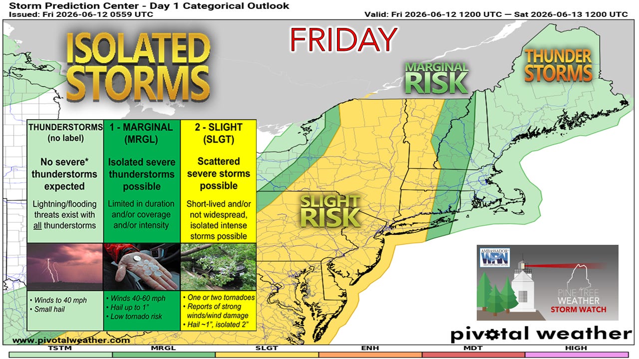
The threat of severe storms has shifted west, per the Storm Prediction Center, which makes sense given the wind coming in off the ocean. The stable air entering with the onshore flow mutes the severe threat.
My main concern for storms that do develop is the threat of strong downdraft winds when heaven unloads.
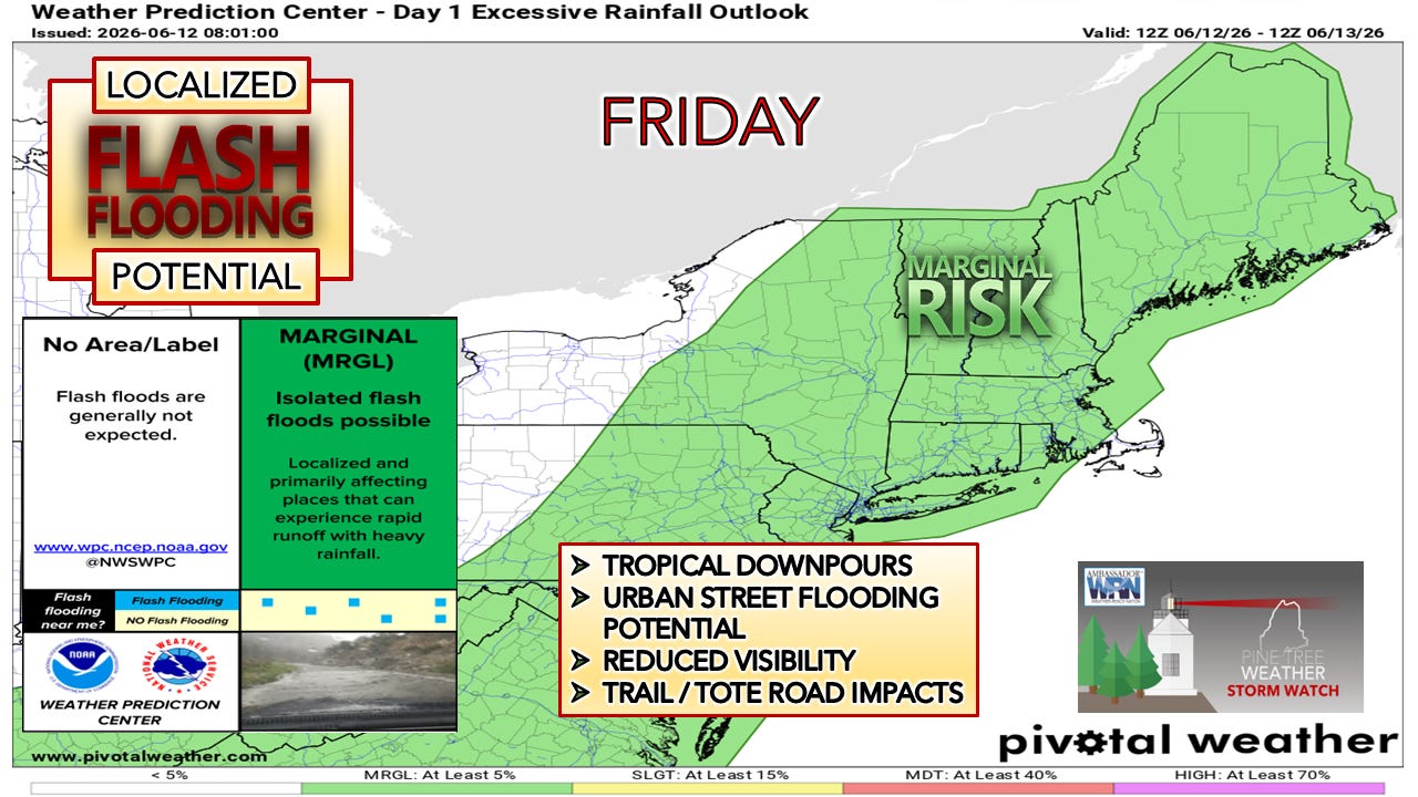
The Weather Prediction Center is in on the game with a marginal flash flood risk. Areas that have received heavy rain in the past two days are at risk where storms develop.
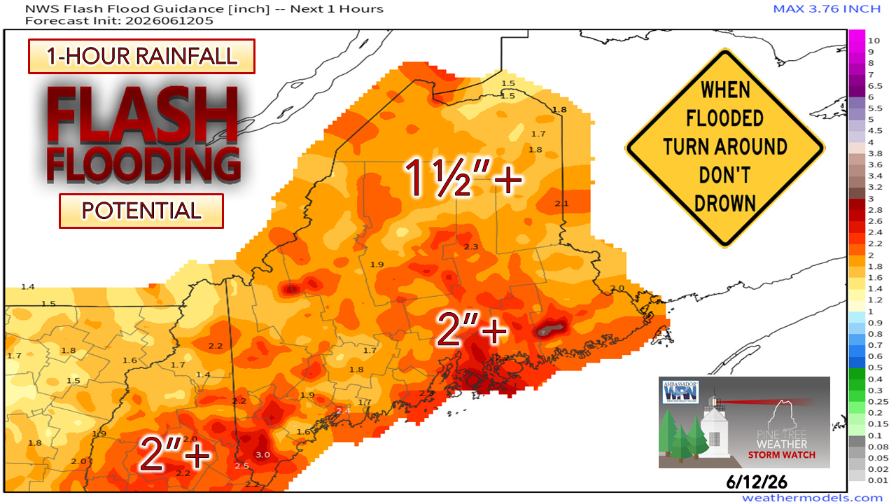
Looking at flash flood guidance, a good portion of the state can’t handle more than an inch or two of rainfall on short notice.
I mentioned yesterday the intrigue of the backdoor cold front working in from New Brunswick, and how the outflow ahead of the approaching cold front from the west may influence shower and storm development.
Friday 7 AM to 6 PM:
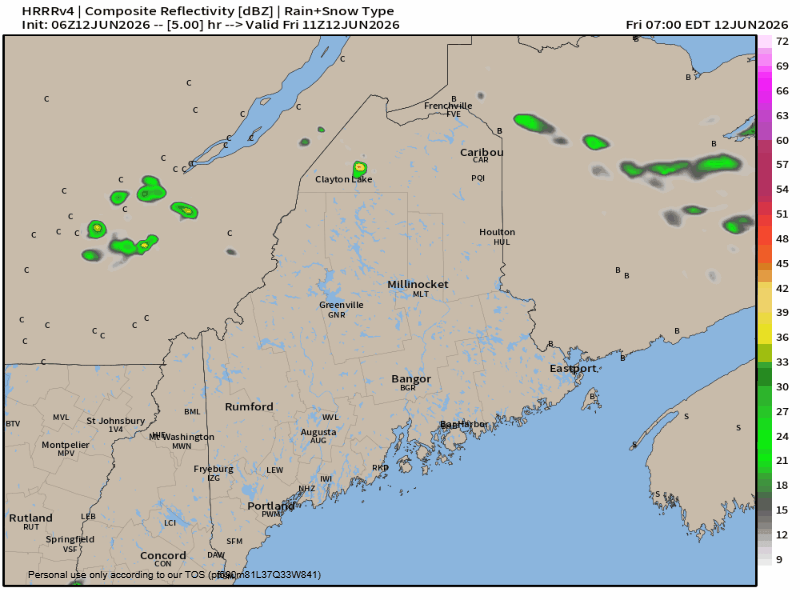
The main concern for storms & heavy rain showers is over the Great North Woods/Moosehead/Baxter regions. This is the vicinity where the backdoor cold front stalls out. Slow-moving dumpers that may backbuild and/or train deliver high rainfall rates. I would not be surprised to see 3”+ rainfall reports to come out of this, with localized amounts upwards of 6”.
Flash flood warnings and areal flood advisories are certainly possible. The rivers, brooks, and streams may load up rapidly.
Areas over the south and west could get 1-2”+ of rainfall with storms in the afternoon, with the pre-frontal trough working in.
Then there is round two…
Friday 6 PM to Saturday 6 AM:

Given the tropical air, overnight dumpers with thunder are possible statewide as the cold front passes eastward. For areas that get hit with heavy rainfall during the day, the threat for more comes overnight. This could add insult to injury in those areas.
Thankfully, the front appears to be moving along at a fair pace, which will push the showers and storms with it.
My word to gardeners and dirt farmers statewide: don’t water today, just in case showers come.
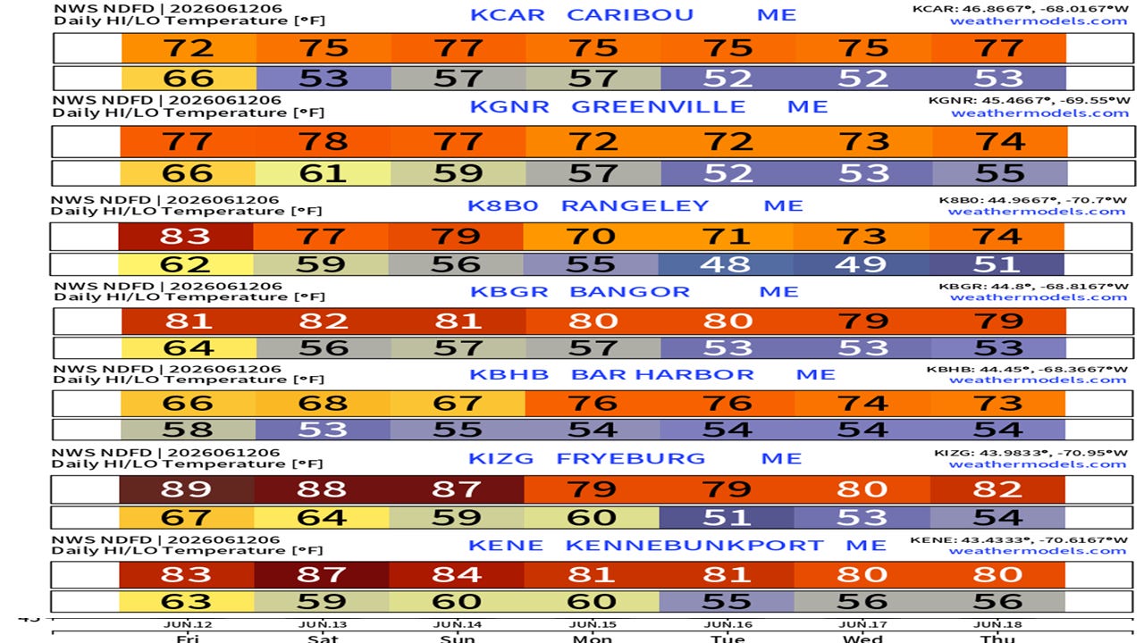
Temperatures and extended outlook
The northwest breeze picks up on the backside on Saturday as high pressure moves in for a brief stay, warming the shorelines and cooling the interior, but humidity will drop and stay away for a few days.
Sunday appears mainly dry for most. The Quebec border region may pick up a shower and/or a storm in the afternoon. Showers with overnight rumbles are possible into Monday.
The broad area of high pressure is dealing with upper-level disturbances trying to chip away at it, which may bring showers to the mountains and north on Tuesday and Wednesday.
The next concern is the potential for a strong low-pressure system to develop near the Great Lakes and track along the St. Lawrence River (aka the inside runner), bringing heavy rain and wind Thursday into Friday. Confidence in the idea is low for now, but it’s not out of the realm of possibility given the upper air pattern.
Stay tuned.

Link: How do I upgrade from being a free subscriber to a paid subscriber?