
Conditional storm threat for interior areas Tuesday
Some rain on the way Wednesday into early Thursday

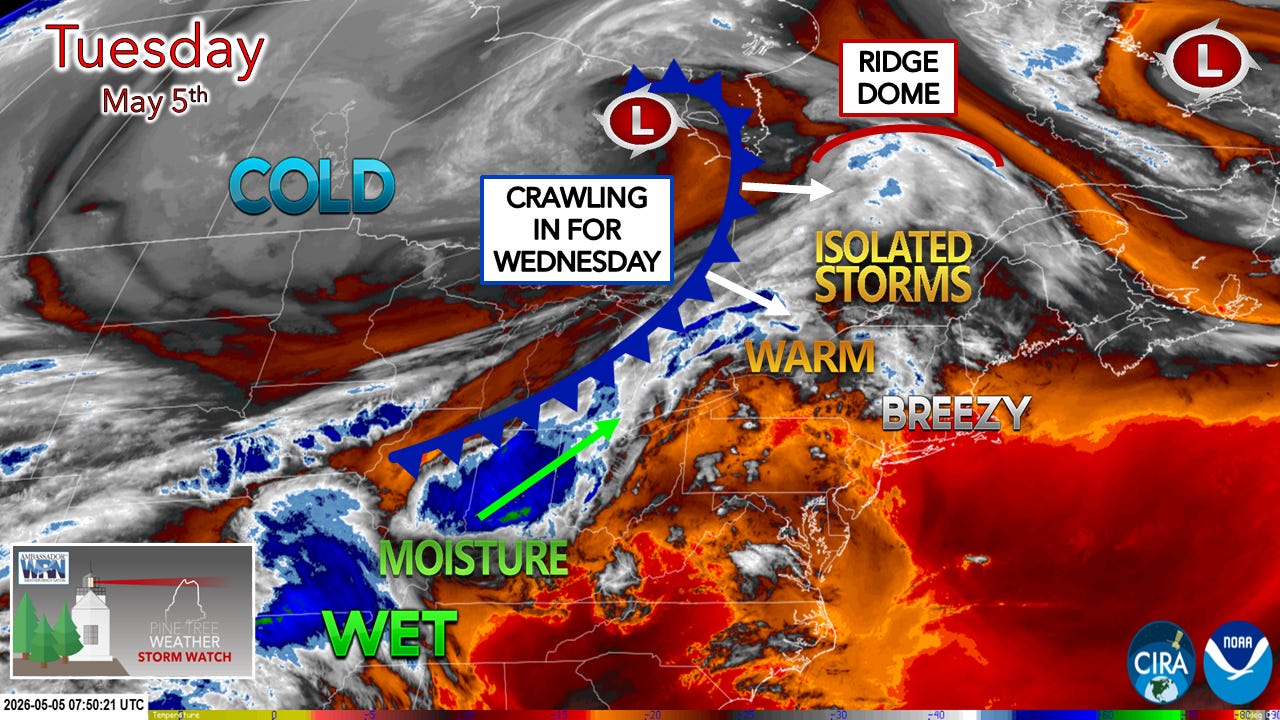
Synopsis
A cold front slowly approaches from the west on Tuesday that may bring isolated severe storms to the west and north late in the afternoon. The cold front slowly passes through the region on Wednesday into early Thursday morning, which could bring a chance for a rumble along with locally heavy rainfall. A cold front/inverted trough scenario approaches from the northwest on Friday, bringing scattered showers. At this point, the weekend appears potentially unsettled, with chances of showers on both days, and may linger into the start of next week.
Forecast changes from Monday’s update
Increased non-storm wind gusts from the southwest with gusts upwards of 45 mph+ possible for the southwest interior, including the Sebago Lakes region, up into the Kennebunk River Valley.
The Storm Prediction Center has added a low risk tornado threat to the west and north.
Potential impacts
Gusty winds over the south may blow debris around and tip over trash cans. It would be wise to secure any loose objects that could go airborne.
Isolated strong-to-severe storms are possible from 2-9 PM over western and northern areas. Storms may train and bring locally heavy rainfall, frequent lightning, damaging wind, hail, and a low chance of a brief tornado.
Non-severe areas of thunder are possible into the overnight hours of Wednesday.
Areas of fog are likely to form over the MidCoast and DownEast shorelines Tuesday evening and may persist through Wednesday.
Locally heavy rainfall is possible with the frontal boundary passage on Wednesday afternoon into early Thursday, with a chance of thunder.
Tuesday
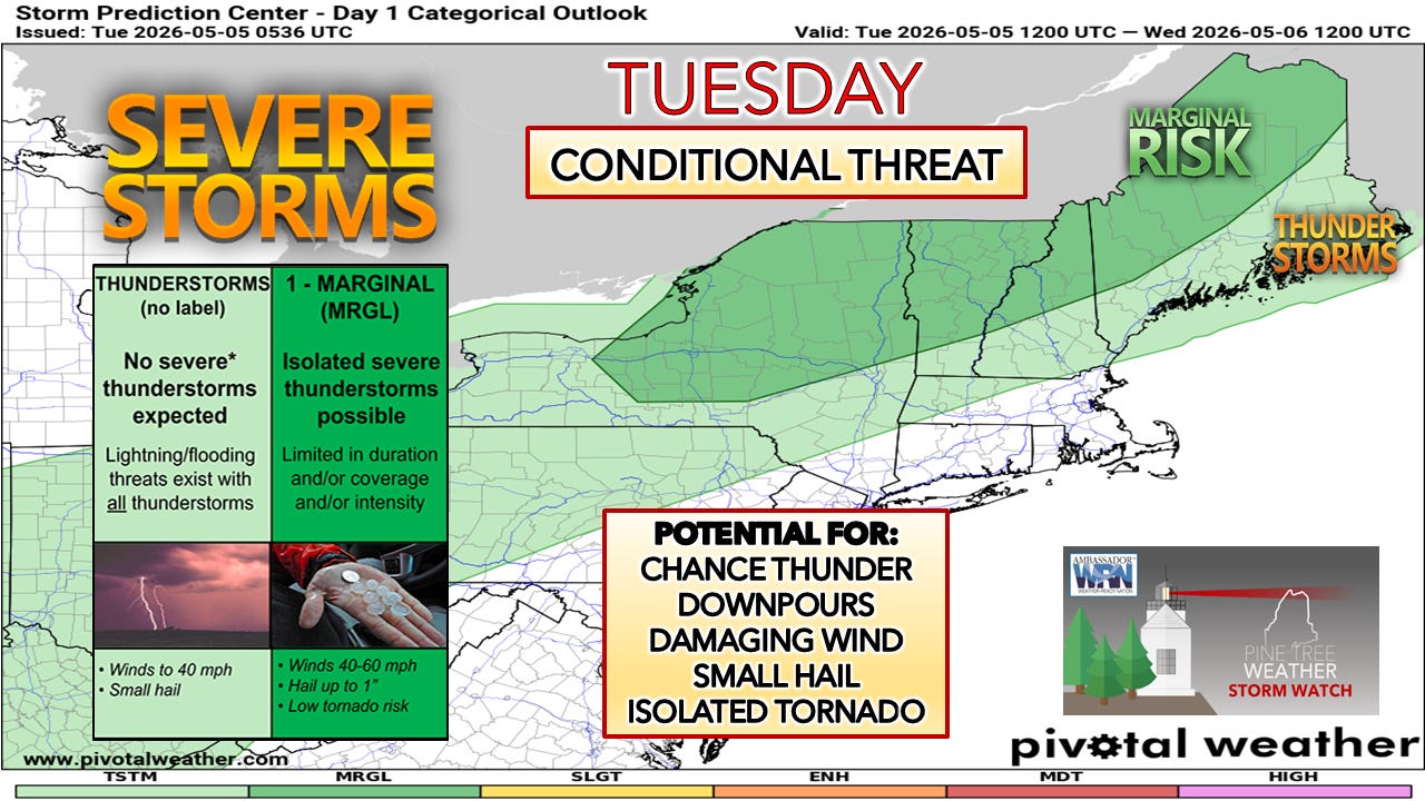
A slight change in thinking from Storm Prediction Center from Monday to include the south and east in the garden variety thunderstorm category, but no changes to the marginal risk region.
There are two key terms on this graphic to keep in mind… isolated and conditional.

Going under the hood with the dynamics and sampling forecast soundings, the damaging wind threat is where greater confidence lies, but it will be a localized threat where storms develop.
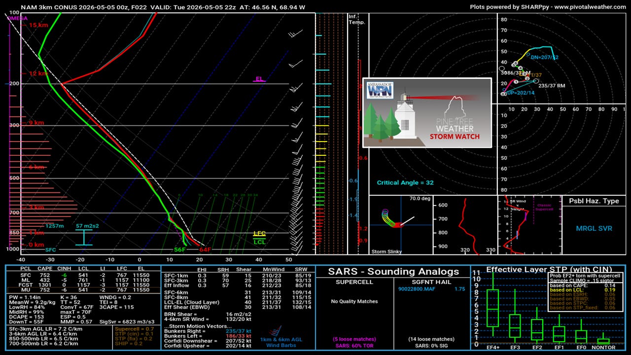
Here’s a sample sounding for the Jackman area, with the forecast point at 6 PM (22z). I don’t want to get too technical here, but there are only a few things I like for isolated severe chances. The wind transport idea from the low-level jet is fair for a damaging wind concern. The freezing layer is below 10,000 feet (700 mb), which supports the risk of hail. The corkscrew effect is in order for spin (top right), which is where the isolated brief tornado comes into play. There is enough convective energy for a supercell to form, but that all depends on cloud cover, which will depend on the timing of the firing of storms over the Eastern Townships of Quebec, and how far ahead the cloud debris from the blown anvils goes ahead of them, which may knock down the threat of anything too crazy.
The dew point temperatures are not great here, in the upper 50s. On our better severe days, mid-60s+ tend to make things more interesting.
This is not a panic situation here. It’s awareness. The first severe chance of the season always gets hyped up. Is there a risk of a couple of snarky severe cells? Sure. The bottom line is this is not a widespread concern, even in the marginal risk region.
I am not a fan of a severe watch being issued for Maine, based on the data I am seeing, as there is a greater threat to the west, in upstate New York and Vermont. I could be wrong, and I am not one to make that decision. If we don’t get a watch, that doesn’t mean severe storms won’t happen. Those in the marginal risk region should monitor the sky, have multiple ways to receive alerts, and take appropriate action if a bulletin is issued.
Rainfall:
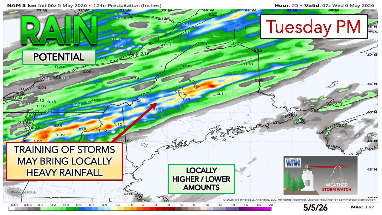
The short-term convective-allowing models are showing streaks, an indicator of the potential for training storms. With dew points in the 50s, I don’t expect localized flooding, but trails and gravel driveways may experience some erosion.
Timing:
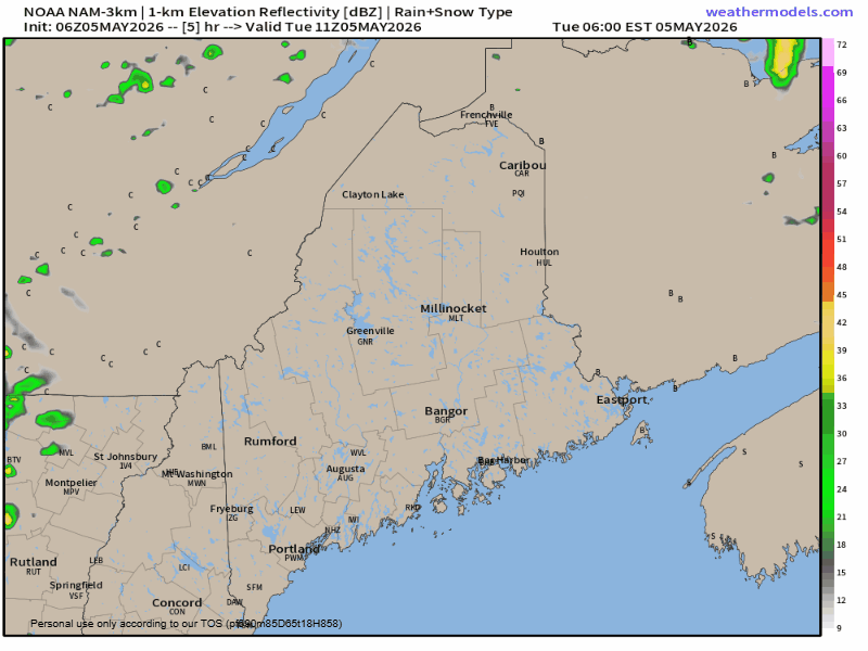
There is a chance of an isolated shower through Tuesday morning. The frontal boundary approaches in the afternoon, with the potential for storms to bubble up in the late afternoon into the early evening. The boundary is forecast to stall out along the St. Lawrence River valley by mid-evening and appear to hang there through Wednesday morning. Depending on where the front stalls, the coastal plain may not get anything more than an isolated shower overnight into Wednesday.
Wednesday into Thursday
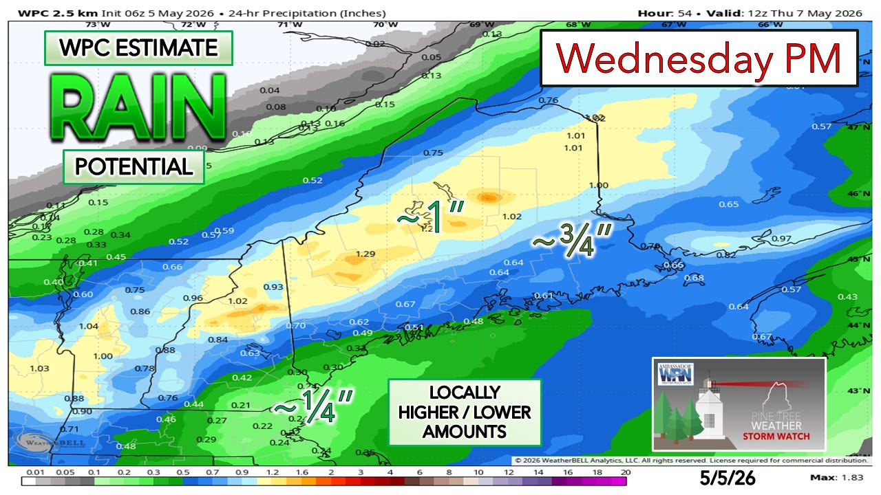
The 24-hour rainfall idea from the Weather Prediction Center, from 8 AM Wednesday to 8 AM Thursday, shows decent rain for the western mountains and into eastern portions of The County, and a fair amount for eastern areas. Guidance is notably lean over the drought dome over the south.
Timing:
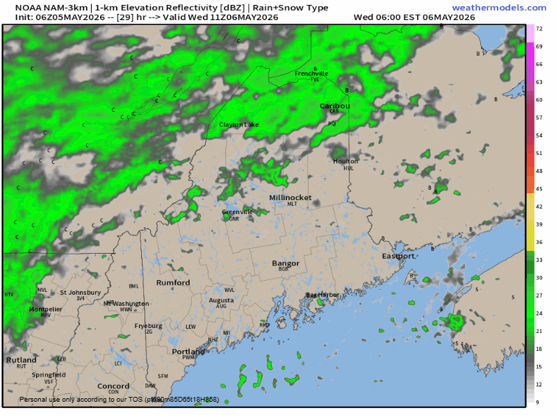
The coastal plain is expected to stay mainly dry in the morning as showers populate over the west and the north. Showers pass through in the afternoon into the evening, and may bring a rumble of thunder given the cold air aloft. I can’t rule out an isolated shower along the coast soon after daybreak, but by then the steady rain and showers will be over by then.
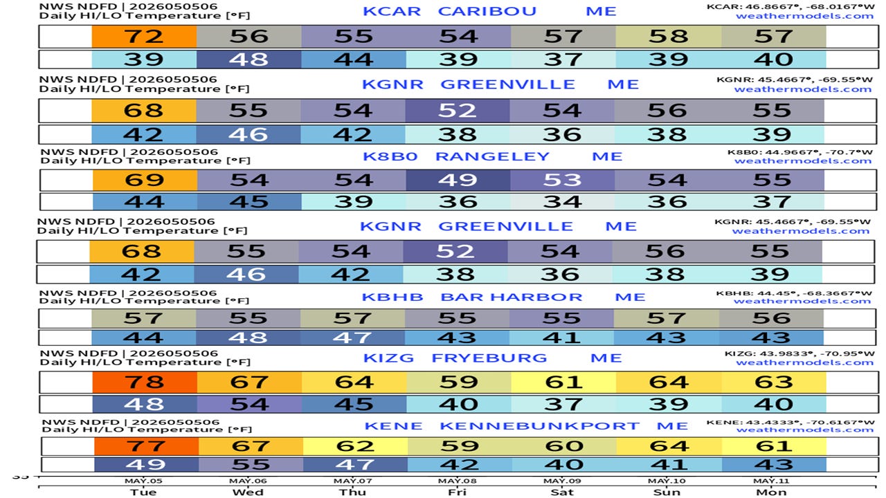
Extended outlook and temperatures
Thursday sees the region dry out. I am watching the potential for an inverted trough that may bring a few showers on Friday. There is a wide discrepancy in ideas for the weekend. For now, there is a chance of showers on both days, with a chance that they may continue into the start of next week. Stay tuned.
Link: How do I upgrade from being a free subscriber to a paid subscriber?


What do you mean by the word "Training" when referring to a storm?